
Photographing Newfoundland - Part I
The Avalon Peninsula
By Dr. Robert Berdan
June 21, 2013
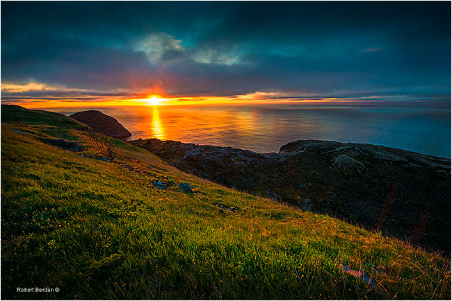
Sunrise over the Atlantic ocean from Signal Hill (70-200 mm lens, 2 Stop ND grad filter).
On my first day in St. John’s Newfoundland I awoke at 4.30 am and roused fellow photographer, Kamal Varma – it was dues time for serious nature photographers. We drove up to Signal hill to photograph the sunrise and saw a fishing trawler far out on the calm ocean. As the sun rose over the ocean the light began to tint the city of St. John’s with its pastel coloured houses and blue harbour. At the mouth of the St. John’s harbour is a lighthouse, Fort Amherst that protects the bay and further south I could see Cape Spear lighthouse in the distant. Sunrise occurred at 5:03 am on May 30, 2013 – this was the beginning of my photographic journey in Newfoundland that was to last just over 2 weeks.
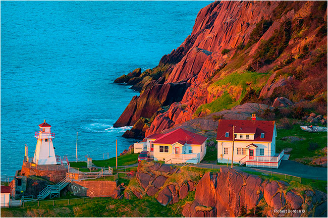
Fort Amherst light house at the mouth of St. John's harbour (Nikon D800, 70-200 mm lens on Tripod).
I had been planning this photographic excursion for almost a year with Kamal Varma and the unique scenery exceeded my expectations. Because we covered more than 3400 km in our rental vehicle I plan to present several articles on photographing Newfoundland showing my favourite photographs. I will also provide resources to places we stayed, dined and I will describe some of our boat excursions in search of wildlife. One of my goals was to bring back some pictures of seabirds especially puffins. Newfoundland is the furthest thing from Disneyland, for the most part its still unspoiled and the homes and fishing villages have a unique charming character that I have not seen anywhere else. The people were uncommonly friendly and the seafood fresh and delicious. Newfoundland is still largely undiscovered from a tourist view point, but as more photographs and beautiful video commercials become more popular tourism could become the most important industry in Newfoundland in the future.
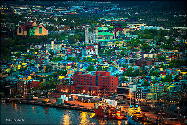
St. John's lit up by the early morning light and photographed from Signal Hill with a 70-200 mm lens.
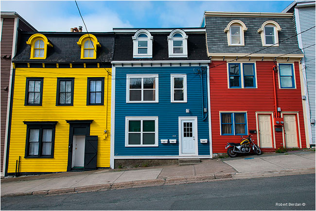
Colourful houses line many of the side streets off Duckworth Street downtown St. John's
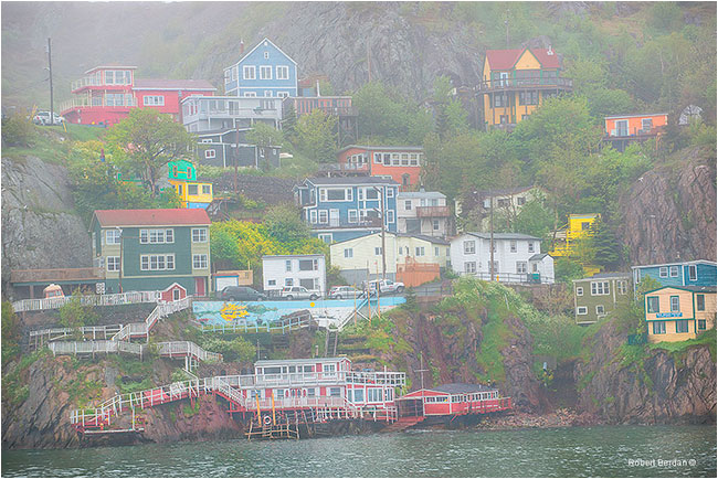
Homes on north cliff face of St. John's harbour on a foggy day.
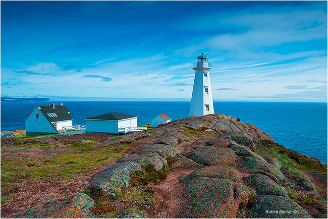
After breakfast in St. John's we started our drive down the Avalon Peninsula along the Irish Loop and our first stop was the lighthouse at Cape Spear, the easternmost point in North America. Construction on the lighthouse began in 1834 and a foghorn was added in 1878. It was clear sunny day with a cool strong wind coming off the ocean.
Cape Spear lighthouse
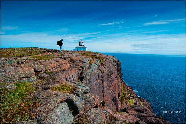
Hiker (Kamal Varma) stops to check his camera above the cliffs at Cape Spear.
Spherical panorama of Cape Spear - to view this interactive movie in full screen - CLICK HERE
After visiting Cape Spear we headed south down highway 11 to Petty Harbour-Maddox Cove before rejoining highway 10. I had travelled this route before using Google's virtual reality (VR) map technology who’s only fault is that their vehicles only follow main paved roads, but I found it to be a great tool for trip planning and identifying potentially scenic locations.
Witless Bay
On our first pass through Witless Bay it was foggy and the town for the most part was just preparing for the upcoming tourist season. On our second visit toward the end of our trip June 12, we stayed at Armstrong's Suites just off the highway and enjoyed a 2 bedroom efficiency unit for only $80\night. Our host also left us fresh berry buns on our table. For breakfast and lunch we visited Judi Devine owner of the Irish Loop Coffee house that overlooks the bay. Judi also offers economical rooms for rent.
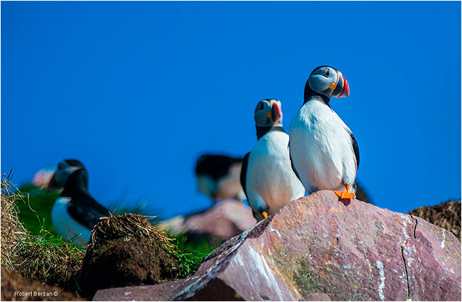
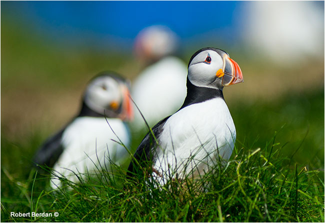
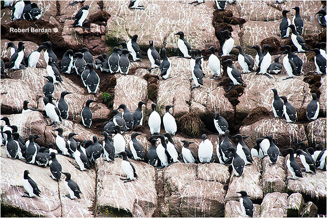
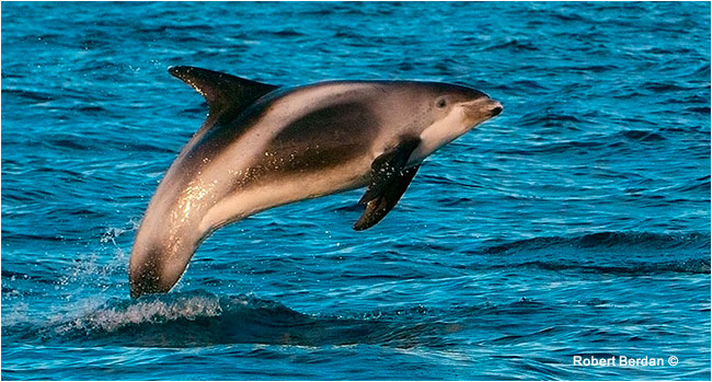
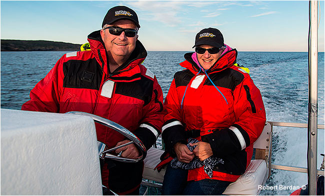
We checked out the two major boat tour operators, Obrien's and Gatherall's. These tour operators are able to take large groups out to the Witless Bay Ecological Reserve. This reserve contains North America's largest Atlantic puffin colony with over 260,000 pairs of the provinces official bird. In addition, black-legged kittiwakes and common murres appear in the thousands. The islands lie just a few kilometers off the east coast between the communities of Bay of Bulls and Witless Bay. Our first trip out with Gatherall's occurred in the morning and it was a foggy one at that. After the trip we explored the coast further south by car and the weather cleared during the day. When we returned later in the afternoon both Obrien's and Gatherall's last tour went out around 2 pm. The captain of Gatherall's ship contacted Captain Wayne's marine excursions who takes out smaller groups and specializes in tours for photographers. This was a lucky break for us, as Captain Wayne and his girlfriend Wendy, also an avid photographer, took us back to the ecological reserve around 6 pm when the light was magnificent. Captain Wayne floated his boat next to the island so we could get very close to the birds resulting in some of the pictures below. Afterwards he took us out further into the ocean in search of whales and we encountered a small pod of white beaked dolphins that performed acrobatics for us. For photographers interested in getting personal attention and close up I recommend Captain Wayne's services if you want a more personal customized tour. Check out Captain Wayne's web site here.
Atlantic puffins
Atlantic Puffins
Common Murre (Uria aalge)
White-beaked Dolphin (Lagenorhynchus albirostris) performing acrobatics beside the boat
Captain Wayne and crew offer customized boat tours for photographers and small groups. Visit his website here.
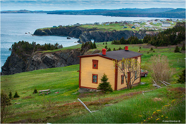
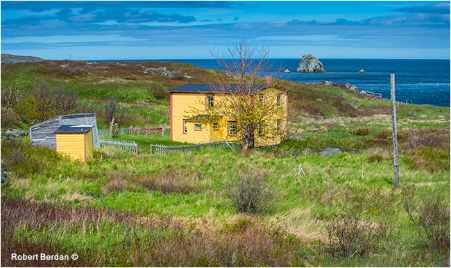
Tors CoveJust south of Witless bay we came to Tors Cove where I was looking for a particular red house that I had seen in the Newfoundland brochure. The location of the house is not indicated in the brochure, but Newfoundland tourism told me it was in Tors Cove but not the exact location. In Tors Cove, I stopped at the Five Island Art gallery for inspiration and to ask for instructions on how to find the red house and they told me how to get to it. The beautiful red house and another nearby white house called the Cribbies is hidden along a small one car wide dirt back road about a kilometer from the art Gallery. This house and scene is also featured in some of Newfoundlands tourism videos because it is so picturesque. The owners were not home, but I was told they lived in St. John's.
While I was at the art Gallery I also purchased up a beautiful book of Paintings by J.C. Roy who painted every cove in Newfoundland over the past 45 years. J.C. Roy describes his style as colourist-expressionist and I was attracted to his brightly coloured paintings and drew inspiration from his book during my visit to the Rock. One thing that is unusual in his paintings is that he often depicts the sun as irregular rectangles or black circles. I came to appreciate his interpretation when I stepped out of my hotel room one morning and looked at he sun through a layer of fog and cloud and it formed an irregular shape of light. You can see an irregular sun in my panorama photo of Cape St. Mary's below. Roy states that if you stare long enough at the sun it will appear black - or damage you vision!. You can view his beautiful paintings or purchase his art book by visiting his web site http://www.jcroy.com/bio_french.htm. Below are some spherical panoramas I took of the inside of the Five Island Art Gallery so you can see how colourful it is.
Five Island Art Gallery I Spherical panorama - to view this interactive movie in full screen CLICK HERE
Five Island Art Gallery II Spherical Panorama - to view this interactive movie full screen - CLICK HERE
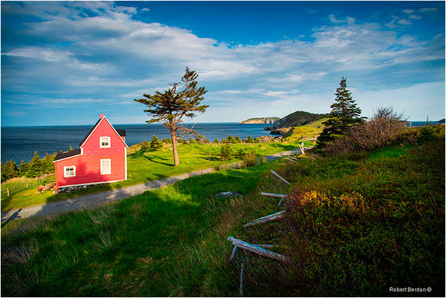
Cottage in Tors Cove - I visited this scenic house on two occasions during the trip. A second home nearby had a small sign on it calling it "The Cribbies". This home is featured in Newfoundland guides and advertisements though I had to hunt and get directions to its exact location. If you are looking for this house stop in at the Five Island Art Gallery in Tors Cove and ask for directions - its only 1 km away on a small back road. One side of the house was under construction when we visited.
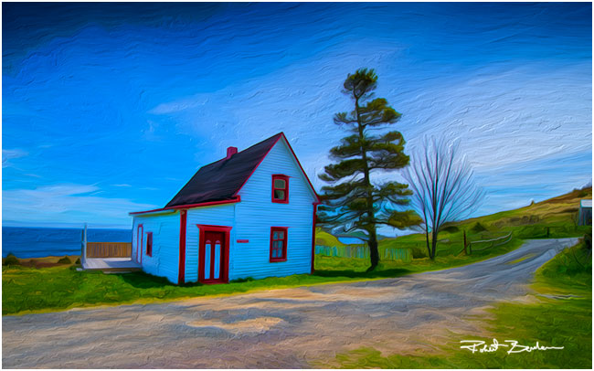
This building was up the road from the red house and had a small sign "The Cribbies" on it. In this Image I applied a Photoshop CS6 oil painting filter to make the image appear more abstract.
Cape Spear
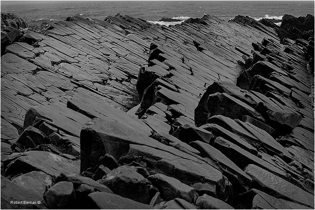
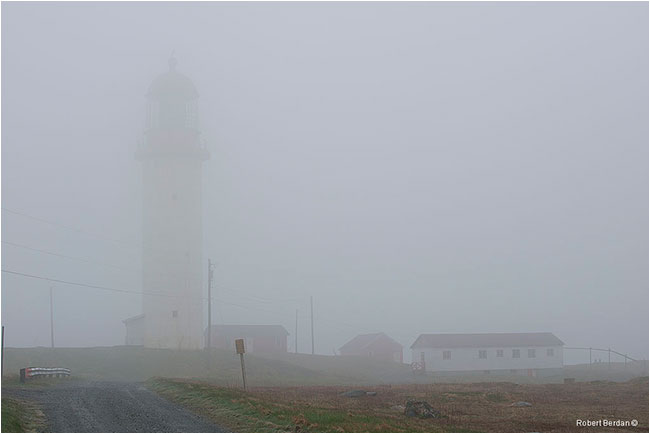
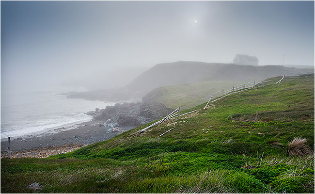
Further down the coast we explored and photographed different coves such as Ferryland, Portugual cove and then stopped to stay overnight in Trepassey. The landscape along this route resembles that of the tundra on my trips to the Northwest Territories. We booked a room at the Trepassey Motel and restaurant. It was foggy and rainy, but we explored the area and next morning drove out to Cape Race along a narrow bumpy dirt road (see below). Our average speed along the road was 20 km, and though surrounded by a light fog we could see the ocean. We stopped frequently to photograph the coast line and rocks. The fossils in this area have been dated to over 560 million years old and a visit to the fossils requires a guided tour by a park officier. When we arrived at the lighthouse it was just barely visible and it was accompanied by the periodic drone of a fog horn. The fog was so thick we could not see the ocean from the lighthouse.
Gravel road to Cape Spear through Mistaken Point Ecological Reserve is about 20 km long ending at the lighthouse
Mistaken Point Ecological reserve has fossils dating back 650 million years - slanted rocks line the coastline.
Summer cottage along mistaken point road
Cape Race lighthouse is barely visible in the fog - each lighthouse puts out a unique pattern of light and sound pulses so they can be distinguished by boats offshore.
Trepassay and St. Vincent's

From Trepassay we headed to St. Vincent’s along highway 10 which then was renamed highway 90 which headed north. There is an interesting road that crosses the mouth of the bay which has a wooden breakwall. I tried to drive on the sandy beach in order to get closer and almost got our Toyota camray rental vehicle stuck. Once we freed our vehicle of sand I ran over to the break wall to take some pictures.
View along highway 10 coming into St. Vincent's - there is a beach on the left with a wooden breakwall
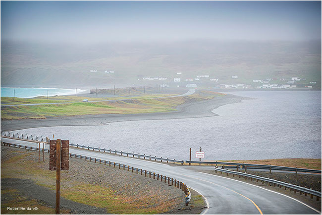
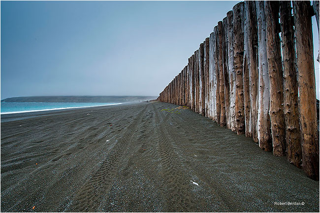
Sandy beach and breakwall which protects the highway from the ocean during storms.
St. Brides
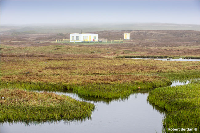
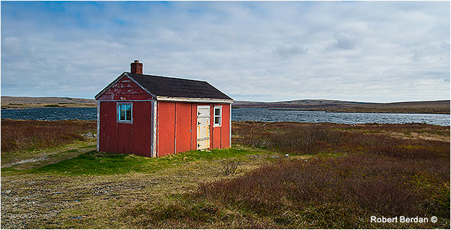
After St. Vincent's we drove around St. Mary's Bay and headed for the town of Branch and then west toward St. Brides. Along most of this route we experienced fog and with tundra adjacent to the highway. We crossed over to St. Bride’s through more tundra stopping only to photograph a small one room house in the middle of no-where that we were told were hunters cabins and places for men to escape from their wives for the weekend.
One room cabin on the tundra for hunters and men that want to get away from their wives for the weekend - at least that's what a local told me.
There are only two hotels in St. Brides and an RV camp. We stayed at the Capeway Motel and Efficiency units, a beautiful 2 story building on the main street. That evening we drove 16 km south to Cape St. Mary’s along a narrow but newly paved road. As we approached the cape we encounterd both clear and foggy conditions that seemed to change from minute to minute.
St. Brides - Gateway to Cape St. Mary's
Cape St. Mary's
We arrived at the visitor center around 7 pm and found it closed. We followed the hiking trail along the cliffs and we began to see clear patches and a magnificent wall of rocks with thousands of birds flying nearby (see movie clip). We hiked along a short I km path through open meadows atop steep cliffs and arrived at Bird Rock – one of the most amazing sites on Newfoundland. This site is home to about 24,000 Northern gannets, 20,000 black-legged kittiwake, 20,000 common mure, 2,000 thick-billed murre, 100 pairs of razorbill, 60 pairs of black guillemot, double crested cormorant, Northern fulmar and countless seagulls.

Hiking at Cape St. Mary's we first encounter the high cliffs with thousands of birds circling above.
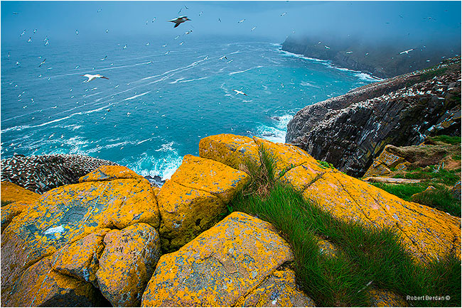
Looking down at the ocean the top rocks are covered in orange lichen with thousands of birds below us.

Northern Gannets cover the rocks at Cape St. Mary's
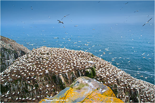
Bird Rock at Cape St. Mary's

Nesting Northern Gannets - they nest in just 6 locations in northeastern Canada
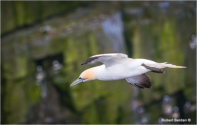
Northern Gannet against cliff face - these birds dive into the ocean head first for surface schooling fish.
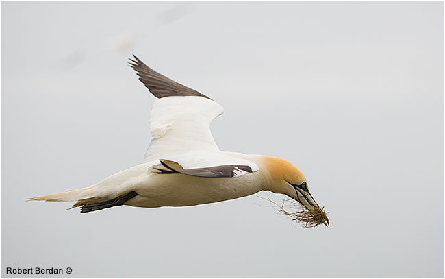
Northern Gannet gatherning grass for its nest - they use mud, grass, seaweed and guano to cement their nest.

Kamal Varma stands beside my camera - Nikon D800, 300 mm f/2.8 lens I used for shooting closeups of the birds.
Short Movie clip of Cape St. Mary's - FLV format requires Flash player

Download and view high resolution panorama of Cape St. Mary's shown above - Free for personal use only.
Cape St. Mary's in my opinion is the most spectacular vista on the island. We spent about 2.5 hours watching and photographing the birds. The nesting birds are only 10 meters away in places. I wish I had brought my spherical camera, instead I tried to photograph the birds with my wide angle lens and also in flight with a telephoto zoom lens and included a few short video clips in order to capture the motion and sound of the birds. I managed to shoot a panorama which you can download a high resolution version above. We had the place all to ourselves for a few hours and we both experienced a photographer’s high afterwards. For anyone visiting the island that is interested in wildlife photography – Cape St. Mary’s ecological reserve is a must see attraction. Just be sure you don't get too close to the cliffs edge.
Sea shore and house in evening fog, St. Brides.
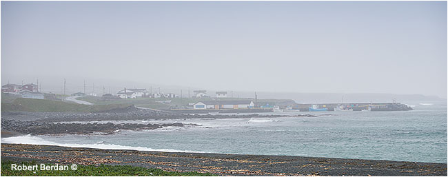
Next morning we hunted for a place to have breakfast but none was open until we reached Placentia after which we drove back highway 100 to the Transcanada and began to explore the northern tip of the Avalon Peninisula driving up highway 80 to Old Perlican a small fishing town. I tried to follow a dirt road up to Daniels cove and further to Grates cove but the road became impassable except for an all terrain vehicle so we turned back and headed to Bay de Verde which was a charming village on the tip of the cape.
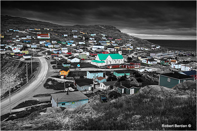
Bay de Verde
Bay de Verde is located on Conception Bay with a population in 2011 of only 398. The village is nestled between two hills that slope toward the ocean. There is dock with fish plant that attracts hundreds of seagulls.
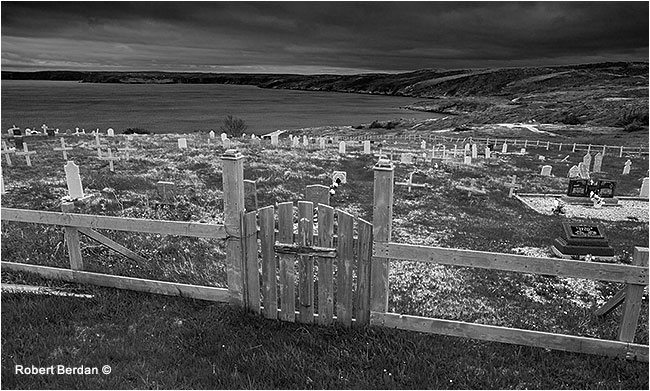
Cemetarys like this one were found all over the island and many of the towns had two or more prominent churches.
There are two churches located in the picture above of Bay de Verde. Photo converted to Black and white and color returned using Adobe Photoshop as described in my Online Photoshop workshops. 70-200 mm lens.
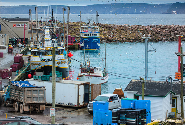
Fish plant and dock in Bay de Verde.
View looking south along highway 70 near Jobs Cove
Perry's Cove
Perry's Cove
From Bay de Verde we drove south along highway 70 photographing many of the small towns along the coast, but I found that south of the town Carbonear the homes became more crowded and lacked the unique style and charm of other remote towns. The area south made me think of Wasaga Beach on Georgian Bay so we decided to drive up north to the Bonnavista Peninusula which I will cover in Photographing Newfoundland Part II.
Lobster traps piled on a dock

Map of our entire trip for the two week journey
We drove over 3400 Km (marked in yellow) in 2 weeks exploring Newfoundland - most of the time we hugged the coastline. The red line indicates the route we took driving the Avalon peninsula shown in this article. On the map I have also marked some of my favorite towns and locations. To view a google interactive map of Newfoundland click here. My journey to other locations in Newfoundland will be described in the next article " Photographing Newfoundland - Part II.
