Ivvavik National Park
Photos and text by Philippe Henry
April 7, 2013
Fig 1. Woman holding a caribou antler.
Located on the north slope of the Yukon Territory, Ivvavik National Park, originally called Northern Yukon national park, was established in 1984 through the settlement of the Inuvialuit Final Agreement, also called the Western Arctic Claim. This agreement established the legal rights of the Inuvialuit people to manage their own land. It is considered to be the first modern land claim. The park has a long history of human activity. An important early archaeological site at Engigstciak, and two sites whith the first Thule Eskimo remains were found. Because the park never experienced glaciation, it was part of an ice-free corridor, known as Beringia, along which people immigrated into North America from Asia. We know that they were here, perhaps as long as 25.000 to 30.000 years ago.

Fig 2. Mackenzie delta.
To get to Ivvavik national park was quite an experience. I reached Dawson, in the Yukon Territory, after driving thousands of miles across Canada from Montreal. Then I drove the famous Dempster Highway and got to Inuvik in the Northwest Territories. Then I flew over the Mackenzie delta and into the heart of the British mountains before landing at Ivvavik Sheep Creek "airport". It was my first visit to a remote canadian northern country and I was amazed by the grandeur of this land. Most visitors come here for whitewater rafting and kayaking, hiking and seeking an arctic wilderness experience. In summer, there are 24 hours of daylight. Most of the time, there is a soft light that offers very good opportunities for photography. I remember one day. After 10 hours of hiking I built my camp up to a mountain and fell asleep around 11.00pm to wake up at 3.00am. In the valley, spruce trees were lit by beams of sunlight shooting up from below the horizon. This landscape, with the pastel blue sky overhead, made me feel like I was part of an impressionist painting. The light was a photographer's dream, the kind of light that emphasizes the beauty of nature.
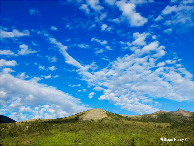
Fig 3. Cloud formation over the mountains.

Fig 4. Firth river valley and British mountains.
I came to the park in july, as a guest of Parks Canada. I spent time travelling along the Firth river to photograph landscapes and geological features. I often pitched my tent on the ridges that dominate the river valley and Sheep creek, where there is Parks Canada's base of operations. During the mini gold rush that took place along the Firth river in the late 1940's, the only placer mine was developed at Sheep Creek. It operated until 1986 when it was purchased by Parks Canada.

Fig 5. Canyon of the Firth river.
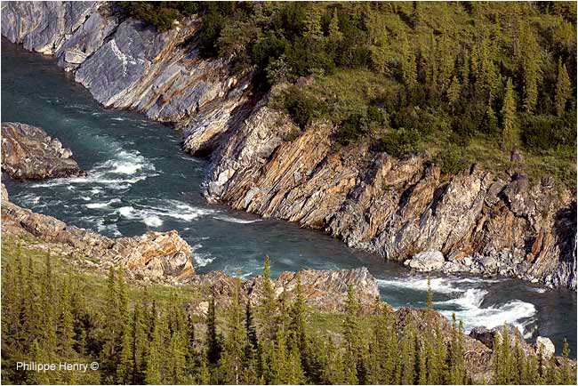
Fig 6. Canyon of the Firth river.
Because this part of the Yukon escaped the last two glacial ages, it means that this landscape has been probably less essentially changed than other landscapes in Canada. It also means the Firth River probably follows much more closely its original course of hundreds of thousands years ago than any other river in Canada. It is probably one of the Canadian oldest river. Originated from the Davidson mountains in the Arctic National Wildlife Refuge, in Alaska, this class IV river is navigable for 130 km, from Margaret Lake, before to join the Beaufort sea at Nunalut Spit.

Fig 7. Canyon of the Firth river.
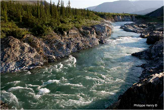
Fig 8. Canyon of the Firth river.

Fig 9. Landscape in the British mountains
The Firth, the Babbage, and the Malcolm river valleys run through the British mountains, in a southwest to northeast direction, towards the Beaufort sea. V-shaped valleys, side-slope rock outcrops and isolated conical hills are typical of these mountains and other non-glaciated landscapes of the park. I have enjoyed walking in the British mountains around Sheep Creek and I had many thoughts coming to my mind. This remote northern land is fragile and will be slow to recover from environmental degradation. Possible development of oil drilling in the Arctic National Wildlife Refuge, that lies just across the park's border in Alaska, would harm the environmental integrity of this outstanding area and the natural heritage it offers to future generations.
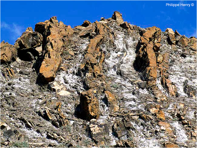
Fig 10. Rock's formation in the Firth river canyon's wall.
Along the canyon of the Firth, the sound of pounding rapids makes one feel the power of Nature. The exposed sedimentary rock introduces you to the region’s geological history. Layers of sediment deposited in an ocean basin between 580 and 380 million years ago is now stone. I spent days photographing geological features like the folded layers of limestone and shale, which show the evidence of mountains soaring skywards when the Earth’s plates collided 400 million years ago, trapping fossilized remains of warm-water animals.

Fig 11. Rock's formation in the Firth river canyon's wall.
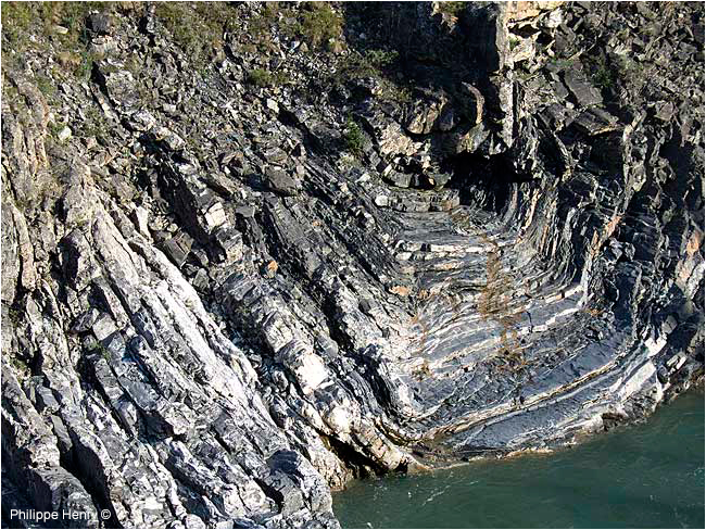
Fig 12. Rock's formation in the Firth river canyon's wall.
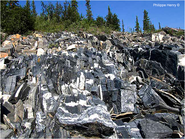
Fig 13. Rock's formation in the Firth river canyon's wall.

Fig 14. Rock's formation in the Firth river canyon's wall.
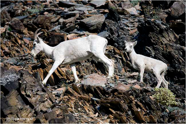
Fig 15. Dall sheep and lamb.
Travelling along the Firth river is the best way to watch wildlife in its natural habitat. In july, In the mountains that surround Fish creek, I saw many Dall sheep that roamed here at the northern limit of their range. I didn't see any caribou. Members of the Porcupine caribou herd had already reached the calving ground along the coast of the Beaufort sea in the north of the park. A large part of the reason for the establishment of Ivvavik National Park, whose Inuvialuktun name means “a place for giving birth and raise young”, was to protect the calving ground for this caribou population.
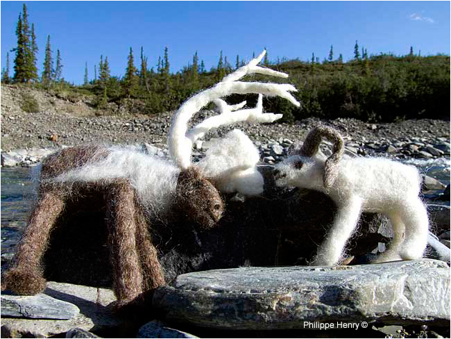
Fig 16. Dall sheep and caribou made by Inuvik textile artist Carolyn Hunter.
Since 2003, Parks Canada's program "Art in the park" attracts to Ivvavik national park artists from the founding culture of this region -the Inuvialuit- and popular artists from across Canada. Together, through different disciplines, they explore and document this wonderful place. Pat Dunn from Parks Canada said -the idea behind the trip is to give the artists eight to 10 days in Ivvavik. Although very few tourists come to visit this remote land, It is important to tell and to show people exactly what the park is about and what it is like to be here. The artists help to do that through their publications and exhibitions.
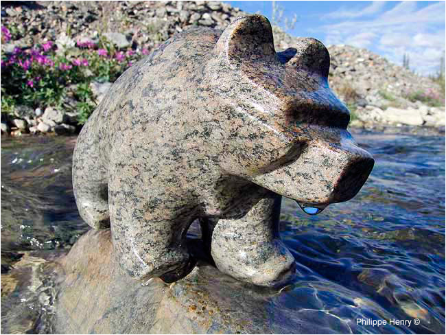
Fig 17. Grizzly Bear made by Deline artist-sculptor Garry Elemie.

Fig 18. Grizzly Bear.
Ivvavik is a bear country. The three bear species call this place home. The polar bears can be encountered along the coast. The black and the grizzly bear range over the entire park but are more common in the British Mountains, along the Firth River, especially during and shortly after the caribou migration. Evidence of the grizzlies is not hard to find. As you walk along the Firth, It is not rare to find large hunks of sod turned over by these majestic creatures digging for roots or arctic ground squirrels. In some places ground has been dug so extensively that it suggests a ploughed field.
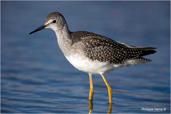
Fig 19. Lesser Yellowlegs.
Ivvavik national park is a nesting place for many bird's species. It is the first place where I saw gyrfalcons, yellow wagtail and bluethroat -in June 2003 Canada's first bluethroat nest was discovered at Craig creek, north of the British mountains. In July, in the bogs around Sheep Creek, I had many opportunities to photograph the lesser yellowlegs. At this time of the year, there is a constant buzzing of bothersome mosquitoes and other insects. The bogs are covered with flowers of cotton grass. I often woke up just before sunrise, around 3.am, to get the best light to photograph these flowers.
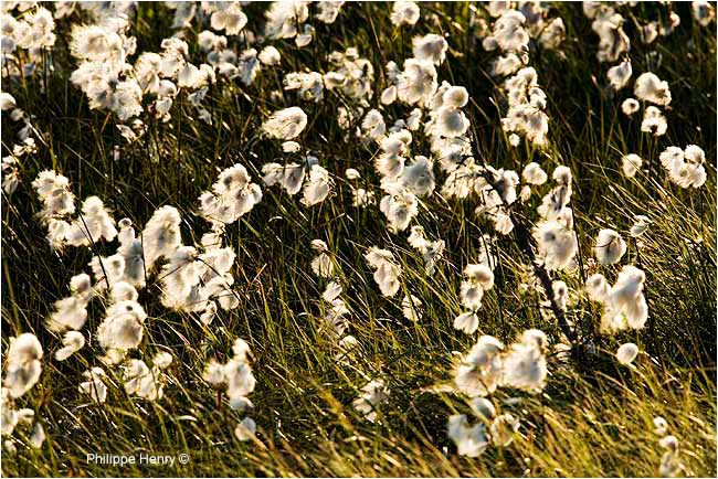
Fig 20. Cotton grass.
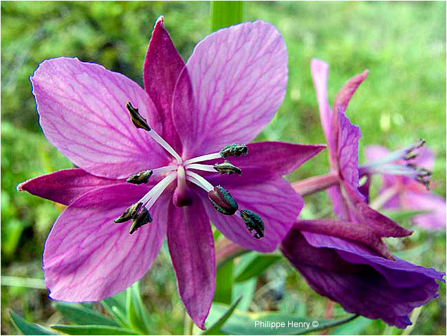
Fig 21. Dwarf fireweed.
Wild flowers are at their best in late June, early July. I have photographed colourful Shrubby Cinquefoil and sandwort on the south-facing mountain slopes of the British mountains. Dwarf fireweed, moss gentian, bladder campions, mountain avens, arctic forget-me-not are also common in the park.
Ivvavik National Park was established in 1984 through the settlement of the Inuvialuit final agreement (western arctic claim), which in turn stemmed from the Mackenzie Valley Pipeline Inquiry in the 1970s. Two gas companies wanted to build a pipeline to move gas from Prudhoe Bay, Alaska, to energy-hungry southern markets across the northern Yukon (including the northern part of Ivvavik national park) to the Mackenzie Delta, then south to the Alberta border.
At the request of Jean Chretien, then Minister of Indian Affairs and Northern Development, British Columbia Supreme Court Justice Thomas Berger embarked on an extraordinary three-year odyssey across the Arctic starting in 1971. He travelled around the North asking experts and ordinary citizens alike what social, economic and environmental changes the pipeline would bring. His report, Northern Frontier, Northern Homeland, was released in May of 1977 and shocked the government that appointed him. He wrote: "… I have concluded that there are environmental reasons for not building a pipeline or establishing an energy corridor along the coastal and interior routes. On the coastal route the pipeline would pass through the restricted calving range of the Porcupine caribou herd and on the interior route it would have a devastating impact on the community of Old Crow."
Berger cautioned that a gas pipeline would be a precursor to an oil pipeline, creating an energy transportation corridor that would require an immense infrastructure of roads, maintenance bases and new settlements to support it. Justice Berger recommended a 10-year moratorium to deal with critical issues — such as settling aboriginal land claims and setting aside key conservation areas — before building the proposed pipeline

|
|
Short Bio: Settled in Quebec since 1994, Philippe Henry, who was born in France, is specialized in wildlife and environment photography. He spends part of his time working with biologists involved with conservation projects. He is also author and illustrator of several books.
Two new books by Philippe that will be published are:
- The Alligator of Texas. Publisher Texas A&M University Press / USA.
- The Andean Bear. Publisher L'Ecole des Loisirs / France
Also see Philippe's previous articles
E-mail: philippe_henry@hotmail.com
Website: www.philippe-henry.com
Tel: (Quebec) + 514 259 0664
Links & Additional Resources
|
[ Top ]
|
