
Bella Coola - Valley of the Grizzlies
By Dr. Robert Berdan
Updated Feb 17, 2012

Boat tours take visitors down the Atnarko river to view Grizzly Bears
Bella Coola is a remote coastal town on the West Coat of British Columbia that is accessible by small plane, boat or by a single steep narrow mountain road called the Heckman pass also nicknamed "The Hill". In places the Heckman pass only allows one vehicle to travel and the right away is given to vehicles travelling uphill. There are no guide rails on this dirt road and should you slip or miss a curve it's a long drop to the bottom. The truckers that travel up and down the Heckman pass have guts (watch Youtube video of the Heckman Pass). On my second trip I brought a small trailer with me, going down wasn't a problem, but pulling the trailer up burned out my transmission. The road has about an average 18% grade, and that might not sound steep, but trust me it is. I can't imagine trying to drive down that road on a winter day though a few folks do. I have visited the valley three times in early September and it is one of my favorite locations to take photographs and one of the best places to see and photograph grizzly bears up close. The entire valley is scenic and is a hikers dream.
At the bottom of the Heckman pass the road becomes paved again and follows along the Atnarko river which is surrounded by rain forest. On this trip I brought my trailer, but won't ever do it again. I also saw folks hunting for mushrooms in the forest next to the highway. You can also drive to Bella Coola with a trailer by way of the BC ferries and avoid the Hill.
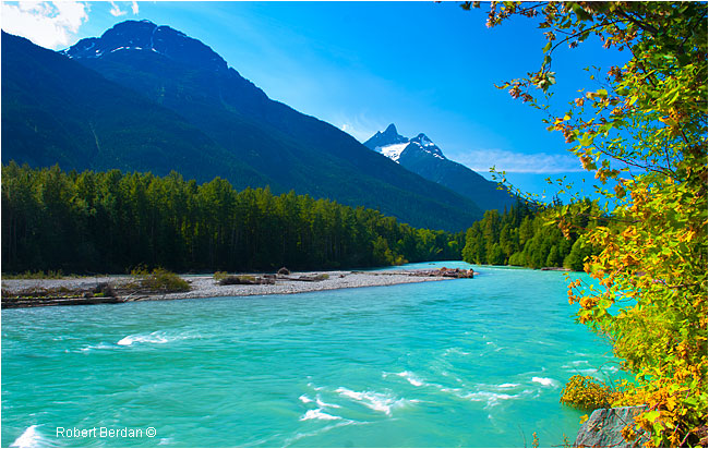
Bella Coola River downstream from the Atnarko/Talchako river confluence
The isolation of the valley is what I find so attractive. As you descend into the valley by car, the vegetation changes drastically, the trees get bigger and are characteristic of the rainforest. The dominant fir tree is Western Red Cedar. The best place to view grizzly bears is in Tweedsmuir provincial park along the Atnarko river. In the Fall, salmon breed in the rivers bringing out the Grizzly bears. There are pull overs next to the river where you can watch the bears from the safety of your car. You can venture out, but be careful and don't invite bears by cooking or eating near the fishing holes. Be bear smart.
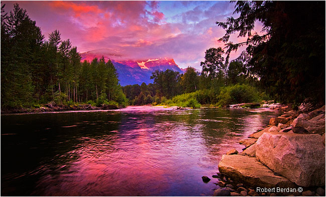
Sunrise at the Atnarko river in front of a popular fishing pool and boat launch. This was a good place to view black bears and Grizzly bears fishing for Salmon in the Autumn, however the area is now closed for bear viewing and is used for boat launches only. There is a new location about 100 mm downstream built by Parks Canada and includes an electric fence (thanks for this update from photographer Michael Wigle who lives in the Valley). Your best chance for bear viewing is to take one of the boat tours down the river.
In autumn you are likely to be accompanied by other tourists and wildlife photographers at some of the fishing holes, be courteous and keep your voice down and leave your radios at home! There are strict rules you need to follow when viewing the bears both for you safety and for the well being of the bears - please read them here. The rules are also posted around some of the viewing sites. Park rangers patrol the fishing holes and viewing areas. If you keep quiet and a low profile you will likely be able to watch bears catch fish. Early morning and late afternoons seem to be the best times to view the bears.
Sow and cub on the opposite side of the Atnarko River at a popular fishing hole - 300 mm + 1.4 X teleconverter. These bears were only about 50 feet away, but the fishing hole separated me from the bears and I felt safe.
Large Grizzly bear eating Salmon - Atnarko River
Mother Grizzly and Cub share a salmon for breakfast along the Atnarko River
Tweedsmuir park is about 45 minutes drive from the town of Bella Cool which offers a marina, hotels, grocery stores, book stores and a small village. There is another small village you will pass through before reaching Bella Coola called Hagensborg. This small village includes campgrounds, grocery store and a hotel. The history of the valley dates back as far as 10,000 years according archeological estimates. The first Native People who lived in villages along the rivers and coastline were known as Bella Coola or Nuxalkmc people. Today the name of the first nations people is shortened to Nuxalk.
Acwsalcta School located in Four Mile Subdivision, displays a magnificent totem pole carved by a teacher and three students. Erected in 2002, it is the first Nuxalk totem pole to be put up in 38 years.
One of the highlights of Bella Coola is a guided hike to the petroglyphs at Thorsen Creek, which archeologists have dated to between 3,000-10,000 years. The area is sacred and requires that you go with a guide and there is a small fee (was $25 when I went and well worth it). The hike is about 40 minutes one way. Our guide indicated that the petroglyphs or rock carvings are about 3.500 years old, but that they are difficult to date. Their age is estimated from the depth of the grooves. To arrange a tour contact the Peteroglyph Gallery - website.
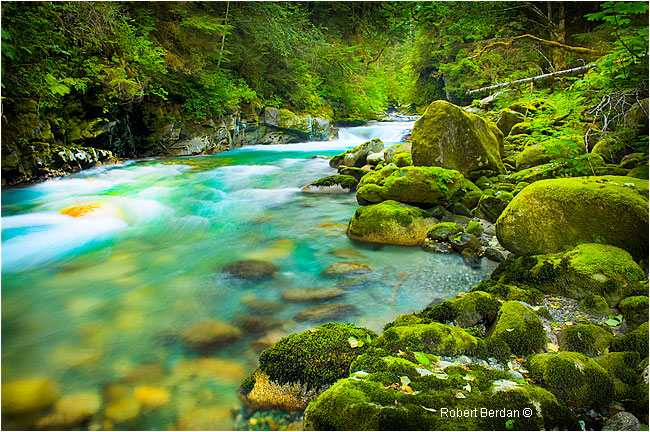
Thorsten Creek - is a small and beautiful with clear pools,waterfalls and salmon swimming upstream.
Face of a warrior carved into the rock. Thor Heyerdahl visited the petroglyphs many years earlier and mentioned how similar they appear to the petroglyphs he observed in the south pacific. Thor Hyerdahl is author of the book "The Kon Tiki expedition" where he sailed 8,000 km across the Pacific Ocean in a raft from South America - one of my favorite books when I was in high school.
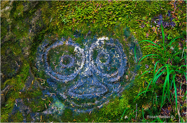
This petroglyph resembles an owl
This petroglyph appears to be an eagle. (The outlines have been enhanced by making them darker using Adobe Photoshop so they can be seen more clearly).
As you drive through Bella Coola toward the marina, you will come to a small park on the ocean and behind the hydroelectric generator is Clayton Falls. The name Bella Coola is thought to come from Kwakwaka'wakx and/or our neighbours, the Heiltsuk, and was taken to be the name of our nation by explorers who met them first. Others believe it may be a Norwegian derivatives, as many Norwegian settlers also made the valley their home (source: www.nuxalknation.org).
Clayton Falls is located just West of the town dock near the Power Plant and is an easy 5 min walk from the parking lot.
Short movie of Clayton Falls
Eagles are perched along the river in autumn as they watch for Salmon in the shallows of the Atnarko River.
Eagles are also common along the coast
Looking toward town and Mount Pootlass in the background - dock and marina in early morning light
Eagles are common around the bay. The valley has most amenities any visitor might want including trailer parks with wireless internet. It takes me a full two days drive from Calgary to reach Bella Coola, but it is a fantastic place to photograph rainforest, grizzly bears, waterfalls and get away from more crowded destinations. For nature photographers the best time to visit is in September when Grizzlies frequent the fishing pools and follow the viewing rules for your safety and the bears.
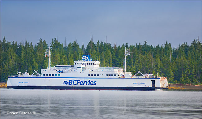
Town dock for the BC Ferry and Marina
BC Ferries comes into town but only during the Summer - so check the schedule below


North Bentinck Arm - Bay leading to the Pacific Ocean

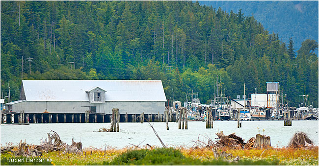
The bay just past town near Clayton Falls there is a small park and path that you can walk along. On the other side of
the bay is out of service Tallheo Cannery.

Grizzly chasing Salmon in the Atnarko River in Tweedsmuir provincial park.
What camera equipment should you bring? I bring all my equipment when I drive from Calgary which takes me a whole 2 days. If you are packing light you will want a telephoto lens for the bears and eagles, bigger is better and safer. If you have large telephoto lens you will also want to bring along a monopod or tripod especially if you want to shoot in low light. A wide angle lens is good for landscapes and a macro lens will allow you to photograph the petroglyphs, mushrooms and flowers found in the valley.
Bears on the West Coast - Bella Coola and The Great Bear Rainforest. (3 minutes) - the latter part of the video was
taken hand-held in a Zodiac boat - hence the bouncy movement.
There is lots to see in Bella Coola, but I visit to take photographs and my favorite subjects are bears, eagles, waterfalls and the petroglyphs The people are friendly and the only thing you need to keep an eye out for when hiking is bears which can appear almost anywhere. We had one come right through our trailer park one morning. If hiking be sure to make lots of noise, bring bear spray, don't hike alone or seek out one of the many local guides. You can also take boat trips on the rivers and out onto the bay. You will definitely get peace and quiet.. Some of the residents in the valley I met also believe they have seen "Big Foot" though I am inclined to believe it was probably one of the many bears in the valley. If you want to see bears the best time to visit is the first few weeks in September, bring a telephoto lens and some patience and you will be rewarded. RB
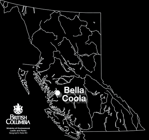
Bella Coola is located on the West Coast of British Columbia at the base of a long ocean inlet and is
surrounded by mountains.

Bella Coola Valley Map - Click on the Map to view an enlarged Map, you can download additional Maps
off the Bella Coola web site link below.
